REGION
The geoheritage of the Świętokrzyskie (Holy Cross) Mountains region have been described in English several years ago in the following paper:
Urban J., Gągol J. 2008. Geological heritage of the Świętokrzyskie (Holy Cross) Mts, Central Poland. Przegląd Geologiczny (Geolological 56, 8/1: 618-628.
https://www.pgi.gov.pl/images/stories/przeglad/pg_2008_08_01_12.pdf
The text of this paper with illustrations is hereafter.
GEOLOGICAL HERITAGE OF THE ŚWIĘTOKRZYSKIE (HOLY CROSS) MTS., CENTRAL POLAND
Jan Urban
Institute of Nature Conservation, Polish Academy of Science, Kraków, al. A. Mickiewicza 33, 31-120 Kraków, Poland
Jerzy Gągol
Polish Geological Institute-Scientific Research Institute, Holy Cross Mountains Branch, Zgoda 21, 25-953 Kielce, Poland
The Świętokrzyskie (Holy Cross) Mts., as a geological region situated within the Trans-European Suture Zone, geological history of which can be studied and reconstructed on the basis of numerous geosites, belongs to the most significant geological heritage of our continent. This history is evidenced by the sedimentary rocks representing every periods from the Cambrian to Jurassic outcropped in this region, whereas “the rest of the stratigraphic table” is accessible in the adjacent Niecka Nidziańska (Nida Basin), with an exception of the Paleogene, presumably occurring in karst forms, but not proved. The geodiversity of the region is accurately illustrated by the area of the Kielce town – the capital of the region, in which the rocks representing all Paleozoic periods crop out. Such a geoheritage should be used in many ways from the elementary public education (geotourism), through professional training (student practices) of earth-sciences, to the modern scientific investigations.
Geodiversity
In the regional geological pattern of the central Europe the Świętokrzyskie (Holy Cross) Mts. region is a part of the Mid-Polish Anticlinorium – the Mesozoic rift inversed during the Laramide (Old Alpine) tectonic movements. The region consists of two principal parts: Paleozoic Core and Permian-Mesozoic Marginal Zone. Additionally it is divided into the two units of different crustal thickness and structure, and different geological evolution (Fig. 1): southern Kielce Unit representing the northern part of the pre-Cambrian-Early Paleozoic Małopolska Block, and northern Łysogóry (Łysogóry-Radom) Unit in the marginal zone of the East-European Platform. Both the segments are separated by the eminent fault of WNW-ESE direction, which was active at least to the Cenozoic, as evidenced by different facies and thickness of sediments, as well as position of gaps and unconformities in the sequences on its both sides (Kutek, Głazek, 1972; Szulczewski, 1995; Nawrocki, 2000; Dadlez, 2001; Narkiewicz, 2002; Mizerski, 2004; Nawrocki et al. 2006).

Fig. 1. Geoconservation in the Świętokrzyskie Mts. and SE part of the Nida Basin. Explanations: 1 – Świętokrzyski National Park, 2 – Chęciny-Kielce Landscape Park; 3 – proposed Świętokrzyski Geopark; 4 – geological nature reserve; 5 – documentary site; 6-11 – nature monuments: 6 – crag or crag group, 7 – cave, 8 – artificial outcrop, 9 – spring, 10 – erratic boulder, 11 – other; 12 – legally not protected geosite described in the text; 13-20 – geological units on the map: 13 – Lower Paleozoic, 14 – Devonian and Lower Carboniferous, 15 – Permian and Lower Triassic, 16 – Middle and Upper Triassic, 17 – Lower and Middle Jurassic, 18 – Upper Jurassic, 19 – Cretaceous, 20 – Neogene. The sites described hereafter are numbered according to the numbers in the text
The Early Paleozoic sequence, commenced in the Kielce Unit with the Lower Cambrian and in the Łysogóry Unit – with the Middle Cambrian (as the oldest formations outcropped) consists of mainly siliciclastic-clayey rocks of the marine origin, which were deposited in the basins surrounding the Baltica paleocontinent. This deposition was interrupted by several gaps, more frequent in the Kielce Unit (Fig. 2). In the same part of the region also the Early Caledonian unconformity (Early Ordovician – Sandomierz Phase) was proved. The Early Paleozoic evolution was finalised with the slight Late Caledonian tectonic movements and hiatus, proved in the Kielce Unit. Several small volcanic intrusions were connected with these movements (Orłowski, 1988; Kowalczewski, 1994; Malec; 2001; Modliński & Szymański 2001a, b; Narkiewicz, 2002; Mizerski, 1995, 2004; Nawrocki et al., 2006).

Fig. 2. Geoconservation in the Świętokrzyskie Mts. and SE part of the Nida Basin on the background of the lithostratigraphic profiles (division of the Permian according to the local scheme). Explanations: 1 – siliciclastic-clayey formation, 2 – carbonate (limestone, dolomite) formation, 3 – marl, 4 – sequence combining clastic, carbonate and clayey rocks, 5 – evaporitic formation, 6 – gap, 7 – volcanites, 8 – hydrothermal calcite-barite-galenite veins, 9 – fragment of the profile not known or discussed. Stratigraphic position of rocks outcropped in the nature reserves, documentary sites and as the nature monuments shown near the lithostratigraphic column using the same symbols as in the Fig. 1; near the symbols the numbers of protected sites (the numbers are higher than total number of protected sites, because the same site may combine more than one stratigraphic unit)
The Lower Devonian shallow marine and occasionally terrestrial deposition of siliciclastic-clayey rocks, was replaced by the carbonate sequence at the beginning of the Middle Devonian (Fig. 2). The shallow carbonate platform, commenced with the extensive deposition of dolomites, quickly evolved into the deeper basin in the Łysogóry part of the region, where the Givetian-Fammenian succession comprises diverse carbonate-clastic-clayey rocks. In the Kielce Unit the shallow carbonate platform lasted till the end of the Frasnian, but its gradual differentiation and drowning, resulted in the development of various depositional environments. In a consequence, the stromatoporoid-coral limestones and dolomites of the Kowala Formation (deposited on this platform) display diversity of structures and faunal assemblages in the upper section. The Fammenian-Lower Carboniferous marly-clayey series was deposited in the deepening basin (Devonian … 1992; Racki, 1993; Skompski & Szulczewski, 1994, 2000; Skompski, 1995; Szulczewski, 1995; Szulczewski & Dvořak 1995; Szulczewski et al., 1996; Malec & Turnau 1997). In the Devonian succession the geochemical and biological global events were reconstructed (Baliński et. al., 2002; Racki & House 2005).
The Variscan movements significantly shaped the tectonic structure of the Paleozoic Core. Although it is considered to be located out of the Variscan Belt, the events of tectonic deformations and associated phenomena, as e.g. mineralization and uplift, resemble evolution of the Variscan Orogene (Rubinowski, 1971; Migaszewski et al., 1996; Lamarche et al., 1999; Mizerski, 1995, 2004; Konon, 2006, 2007; Urban, 2007). During the Late Permian the region was a mountainous peninsula on the east margin of the Central European Zechstein Basin. So very variable sediments ranging from the immature, coarse-grained clastics to the lagoonal limestones were deposited around it (Wagner, 1994; Skompski, 1995; Szulc & Becker 2007).
Since the Early Triassic the Świętokrzyskie Mts, as the south-eastern segment of the Mesozoic rift called Mid-Polish (Danish-Polish) Through, underwent to the subsidence of various rate, along the axis stretched NW-SE. The subsidence did not mean the unification of the depositional environments and facies (Kutek & Głazek 1972; Hakenberg & Świdrowska, 1998a, b; Lamarche et al., 1999; Kutek, 2001). The siliciclastic-clayey rocks deposited in the terrestrial environments with participation of marine episodes are characteristic for the Early Triassic, Late Triassic and Early Jurassic periods (Fig. 2). The thickness of these sequences increases principally toward the north-west, whereas in the south-eastern and central parts of the region the gaps and erosion are proved. In turn, the extensive shallow carbonate basins covered the Świętokrzyskie Mts. in the Middle Triassic (Germanic Basin) and Late Jurassic (Szulc, 2000; Pieńkowski 2004; Wierzbowski et. al., 2006; Szulc & Becker, 2007).
The Cretaceous and younger formations belong formally to the geological units surrounding the Świętokrzyskie Mts, but they are easily accessible (outcropped) not far from this region, in the adjacent south-eastern part of the Nida Basin, called Ponidzie. After the Late Jurassic-Early Cretaceous hiatus, the deposition in this part of the Nida Basin, commenced with the clastic or clastic-carbonate series of the Albian or Cenomanian. The deposition in the Late Cretaceous basin, covering the whole central Poland, produced the thick series of marls and marl-siliceous rocks (gaizes) with limestone inserts (Fig. 2) (Kutek & Głazek, 1972; Hakenberg & Świdrowska, 1998b; Walaszczyk, 1992).
Since the tectonic inversion and uplift of the Mid-Polish Anticlinorium in the Laramide Phase, the central part of the Świętokrzyskie Mts. region has been permanently or almost permanently under the terrestrial conditions. The prolonged erosion resulted in the removal of 1-3 km thick series of rocks from its central part. In the Neogene the region belonged to the elevated Meta-Carpathian Arch, which was hydrological divide between the Northern-Central Europe and Paratethys Basin (Fore-Carpathian Depression). The shallow sea of this second basin invaded the southern margins of the Świętokrzyskie Mts (Kutek & Głazek, 1972; Głazek, 1989). The Middle Miocene marine sediments of the south-eastern part of the Nida Basin are represented by bioclastic or lithoclastic carbonate rocks grading upward and toward the south into clayey sediments (Radwański, 1969; Krysiak, 2000). The evaporite series occurring within this sequence is characterised by sedimentary structures of gypsum and diversity of gypsum crystals, among which are giant forms (Kasprzyk, 1999; Bąbel, 1999, 2002).
In the Pleistocene the region was under an ice-sheet during the South-Polish Glaciations and partly (northern part) during the Mid-Polish Glaciations. Apart from the glacial processes, the relief was shaped by morphogenic factors typical of the periglacial and interglacial environments (Klatka, 1962; Lindner & Wojtanowicz, 1997). Currently the Świętokrzyskie Mts. are characterised by structural relief. Low mountain (hill) ranges are formed of hard rocks, resistant for weathering-erosion in warm (Neogene) and moderate-cold (Pleistocene) climates, as quartzitic sandstones, sandstones and limestones (Olędzki, 1976). In turn, the wide and flat valleys are filled with the Pleistocene glacial, glacifluvial and fluvial sediments.
The diversity of rock and mineral formations has stimulated a man’s interest in mineral resources exploitation since the human existence in the Świętokrzyskie Mts. During the New Stone Age flints were mined in hundreds of pits and underground galleries on the Upper Jurassic limestone outcrops of the northern part of the Świętokrzyskie Mts. The mining and processing of iron ores (mainly of sedimentary origin) started in the central part of the region at least since the Late Iron Age (2nd century BC) and was closed in the second half of the 20th century. Lead and copper ores of the hydrothermal and karst origin were mined since the Middle Ages till the half of the 20th century (Rubinowski, 1971). The long and complex tradition of the interconnections between a man and abiotic nature is expressed with various natural-historical features. The most common are the surface remnants of mining, as hundreds of shaft depressions and waste rocks dumps. Less frequent are open shafts, mine galleries and remnants of metallurgy works. The most impressive monuments of historical mining are three statues sculptured in the large blocks of galenite (Fig. 3) and the legend on their extraction in the 17th century.

Fig. 3. Monastery on the Karczówka Hill, Kielce – the statue of St. Barbara (a patron of miners) sculptured in the large block of galenite mined in 1646 (photo M. Kuleta)
The quarrying, begun about one thousand years ago, has developed into one of the main industry branch in the region, now. The principal historic types of block building stones were: white-pink-red hydrothermal calcites, reddish and brownish-grey Devonian limestones, Permian carbonate conglomerates, “soft” light grey Miocene limestones, Lower Triassic red sandstones and Lower Jurassic grey-yellow sandstones (Urban & Gągol, 1994; Gągol, 1996). Now the stone materials are commonly quarried for the construction and road industry (balast, concrete, lime and gypsum cements), chemical industry and agriculture (fertilisers).
Geoconservation
The unique scientific and educational values of the Świętokrzyskie Mts. for geological studies in central Europe were appreciated by the first geologists working on this territory, at the beginning of modern geology. This fact was the reason to foundation the first Polish Mining Academy (active 1816-1826) in the Kielce town. J. B. Pusch (1790-1846), the author of the first modern monograph on the geology of Polish territory, described many of geosites mentioned below. In 1843 other geologist, L. Zejszner (1805-1871), guiding Sir R. I. Murchison during his travel to central and eastern Europe, demonstrated him the Devonian geosites in the Kielce town and the Neogene paleofauna in Korytnica (see below).
The first proposals of legal protection of geosites in the Świętokrzyskie Mts. were articulated just after the First World War (when Poland gained its independence after 123 years of dismemberment). The most active in this field was eminent Polish geologist, J. Czarnocki (1889-1951) proposing the establishment of the Świętokrzyski National Park and protection of other geosites (Czarnocki 1928a, b, 1949). The current state of the inanimate nature protection in the region was initiated by geologist Z. Rubinowski (1929-1997) and realised in the eighties of 20th century (Urban 1990). Now in the Świętokrzyskie Mts. the network of legally protected geosites constitutes: 28 nature reserves, 145 nature monuments and 14 documentary sites. To the protected areas comprising the geosites of scientific-educational values should be also assumed the Świętokrzyski N.P. and 9 landscape parks.
Among the protected geosites are typical rock sequences (also stratotypes), outcrops of sedimentary structures, tectonic phenomena, paleontological sites, sites of occurrence of interesting mineral/rock formations and historical mines, crags, caves, paleokarst forms, erratic boulders and springs. The protected geosites represent almost every units of the stratigraphic profile (Fig. 2). The list of protected sites should be supplemented along the development and progress of the scientific researches of the region.
Geosites
Using the adequate criteria (Dingwall et al., 2005), the geosites of the Świętokrzyskie Mts. were assessed in order to selection of sites of super-regional importance as candidates for the European Geoheritage List in a framework of the “Geosite” project (Wimbledon, 1999). The preliminary list was proposed in 1999 (Urban & Wróblewski, 1999) and resumed in 2006 (Alexandrowicz, 2006 and “Polish database …” on www.iop.krakow.pl/geosites/default.asp). Several geosites proposed for the list are presented hereafter.
- Łysogóry Range (Świętokrzyski National Park)
The Łysogóry Range is the highest mountain range in the Świętokrzyskie Mts. (612 m a.s.l., ca 300 m above the surrounding plains). The range is formed of Upper Cambrian quartzitic sandstones (Kowalczewski, 1994; Żylińska et al., 2006), which belong to the Łysogóry Anticline – asymmetric fold or scale stretched WNW-ESE. The south margin of the fold is identified with the super-regional Świętokrzyski Fault, separating two units of the Earth crust: Łysogóry (-Radom) Unit and Kielce (-Nida) Unit (Małopolska Block) (Dadlez, 2001; Mizerski, 1995, 2004).
The Łysogóry Range is structural landform, famous because of fields of large angular “quartzite” blocks (Fig. 4), which cover its slopes (“łysogóry” means „bald mountains” in Polish). The field blocks developed in the periglacial environment of the Late Pleistocene, due to the mechanical weathering and subsequent solifluction and pluvial erosion. The gradual retreat of the block field margins and progress of plant cover has been observed recently (Czarnocki 1928a, Klatka, 1962; Olędzki, 1976; Huruk, 1986).
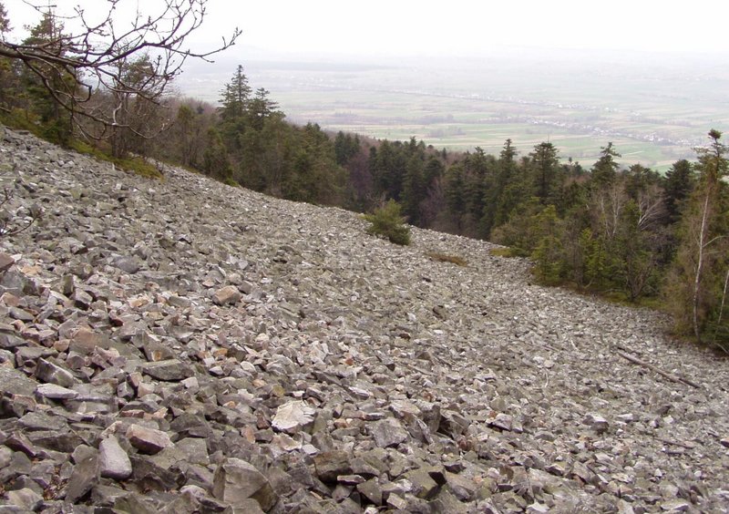
Fig. 4. Łysogóry Range – block field on the northern slope of the range (photo J. Urban).
- Mójcza (site legally not protected)
The condensed sequence of the specific Upper Ordovician sediments crops out in the artificial trench ca 15 m long. The most interesting Mójcza Formation, represents the Upper Arenig through Upper Caradoc (biostratigraphy proved by conodonts). It is 8,5 m thick and almost continuous, with the bentonite horizon of correlative importance. It is formed of the bedded biodetritic and oolithic limestones – grainstones, in the uppermost part packstones to wackestones (Fig. 5). Fossils are represented by conodonts, ostracods, crinoids, brachiopods, bryozoan zoaria, trilobites and molluscs (new taxa). The Mójcza Fm was deposited in stable environments of submerged platform separated from the source of the terrestial material. The formation of platform was related to the sea-level highstand after Llandwirn transgression and then to the next trangression in the Late Caradoc-Ashgil time (Dzik, 1994; Trela, 1998, 2005).

Fig. 5. Mójcza site – the trench with the limestone sequence of the Mójcza Fm; on the limestone surface the traces of sampling (photo J. Urban)
- Grzegorzowice-Skały (partly in the Wąwóz w Skałach Nature Reserve)
The Early to Middle Devonian rock sequence is exposed in a chain of outcrops scattered on the slopes of Dobruchna creek valley in the distance 3.5 km. The units in this sequence are as follow: a) Zagórze Formation (Emsian) – terrigenous to shallow marine sandstones bearing placoderms; b) Grzegorzowice Fm (Upper Emsian-Lower Eifelian) – marine sandstones, shales, marls, limestones and dolomites bearing conodonts, corals, crinoids, brachiopods, ostracods, trilobites, conodonts and acritarchs (stratotype) (Malec, Turnau 1997); c) Wojciechowice Fm (Eifelian) – dolomites with limestone and marl inserts (outcropped in a quarry and as natural crags), rich in stromatoporoids, corrals, brachiopods (Fig. 6) and crinoids, deposited in shallow water environments (Skompski & Szulczewski, 1994); d) Skały Beds (Eifelian, Givetian) – shales, marls and limestones full of fossils: brachiopods, crinoids, ostracods, corals, gastropods, lamellibranchs, tentaculitids, conodonts, trilobites and nautiloids; e) Świętomarz Beds (Middle Givetian) – claystones and siltstones with paleoflora and rare fauna; f) Pokrzywianka Beds – limestones bearing stromatoporoids, corals, brachiopods, ostracods and trilobites; g) Nieczulice Beds (Upper Givetian) – claystones, marls and limestones with brachiopods, nautiloids, goniatites, ostracods, crinoids, radiolarians and conodonts. Stratigraphy of the sequence are proved by conodonts, ostracods and miospores (Szulczewski, 1995; Malec & Turnau, 1997).

Fig. 6. Skały abandoned quarry – the „Stringocephalus Bed”, a limestone layer bearing brachiopod fossils (new taxa) within the dolomite series of the Wojciechowice Fm (photo J. Urban)
- Kadzielnia (partly in the nature reserve), Kielce town
The Frasnian shallow marine limestones, overlain by Fammenian marly-shale series deposited in the deeper basin, crop out in the abandoned quarry of Kadzielnia. The Lower Frasnian bioherm of the Kadzielnia Limestone is mud-supported mound rich in microbiotas, stromatoporoids and corals. Slope of the mound is covered by biodetrital limestones (Detrital Stromatoporoids Beds). Both these units are flanked and partly covered by micritic Manticoceras Limestone, which compensates depression near the depositional buildup. The Frasnian carbonates are covered discordantly by layer of the Lower Fammenian Cheiloceras Limestone unit and marly-shale series (Fig. 7a). The Frasnian carbonates were formed in the northern part of the Middle-Late Devonian carbonate platform. Stratigraphy of the sequence is proved by conodonts, but many groups of fossils: corals, brachiopods, goniatites, moluscs, stromatoporoids, crinoids, ostracods, trilobites, tentaculites, foraminifers and fishes) have been studied there for the last century (Szulczewski, 1971, 1995; Rubinowski & Wójcik, 1978; Devonian …, 1992; Racki, 1993; Szulczewski & Dvořak, 1995).
The Devonian carbonates are cut by large Variscan fault, rejuvenated and karstified in the Cenozoic, as well as the Permian-Triassic hydrothermal veins of calcite-barite-galenite mineralisation (Rubinowski, 1971). Remnants of the Permian-Triassic karstification, and abundant Cenozoic karst forms occur in the limestone (Fig. 7b). Large paleo-sinkholes filled with sands are supposed to be of the Paleogene age. Bones of the Early Pleistocene vertebrates were excavated in fills of karst caverns (Kowalski, 1989). 25 caves registered in the quarry belong to the karst system developed on two or three levels in the Neogene and Early Pleistocene (Czarnocki, 1949; Kozłowski et al., 1965; Rubinowski & Wójcik, 1978).

7a

7b
Fig. 7. Kadzielnia abandoned quarry: a) Frasnian massive limestones overlain by Fammenian marly-shale series; b) Skałka Geologów (Geologists’ Rock) on the background of the Kielce town. The Frasnian massive limestones are strongly karstified, which is illustrated by the brown fills of deep paleodolines (photo J. Urban)
- Śluchowice (Jan Czarnocki Rock Nature Reserve), Kielce town
Unique tectonic meso-structures developed due to the Variscan tectonic movements in the Upper Devonian (Frasnian) bedded limestones, crop out in the high faces of the rocky “neck” separating two abandoned quarries. The main outcropped structure is a recumbent flexure fold (turned to the south) with subordinate foldings in its wide axial zone (Fig. 8). Characteristic elements of these forms – flexural slips, bulbous hinge structures, hinge gaps, hinge neck, and system of various faults, joints and clevage in the folded layers, etc. – enable detailed studies of the mechanism of folding (Czarnocki, 1949; Konon, 2006, 2007).
The sequence (Kostomłoty Beds) was deposited in the distal, slope part of the Upper Devonian platform, in deeper sea than in Kadzielnia site. Several groups of fossils were found in the rocks: brachiopods, corals, trilobites and conodonts (Szulczewski, 1971).

8b

8a
Fig. 8. Śluchowice (Ślichowica) abandoned quarry: A) a general view on the fold structure,B) detail – a deformed axial part of the fold (photo J. Urban).
- Wietrznia (Zbigniew Rubinowski Nature Reserve), Kielce town
Wietrznia abandoned quarry is an outcrop of the Middle to Upper Devonian carbonates, as well as Permian, Triassic and Cenozoic paleokarst. Owing to dip of the Devonian rock strata, the stratigraphic sequence ranges from the Givetian to Fammenian. Givetian-Frasnian thick-bedded and massive carbonates (Wietrznia Beds) represent biodetrital deposits of the distal part of the carbonate platform drowned during the Late Devonian. They pass upward to the micritic limestones and Fammenian thin-bedded marls. Syndepositional movements of small tectonic blocks generated facies diversity observed within the quarry. The rocks are abounding with fossils: corals, brachiopods, goniatites, moluscs, stromatoporoids, crinoids, ostracods, trilobites, foraminifers, conodonts and fishes, which have been investigated since the 19th century. These studies resulted in: a) description of new taxa, b) analyses of anatomy and evolution, c) stratigraphy of the sequence (Givetian-Frasnian boundary), d) reconstruction of the evolution of faunal assemblages and their reaction on the Devonian global events (Czarnocki, 1949; Devonian …, 1992; Racki, 1993; Skompski, 1995; Szulczewski, 1995; Szulczewski & Dvořak, 1995; Baliński et al., 2002; Ivanov & Ginter, 1997; Vierek, 2007).
The relics of the post-Variscan terrestrial period in the Wietrznia quarry are as follows: a) Permian brecciation zone and megabreccia, which fills large paleokarst doline, b) Permian-Triassic sinkholes filled with the carbonate grading upwards to clastic sediments, c) Early Triassic tectonic-karst fissures filled with sandstones. The diversity of forms and fills suggests several phases of the erosion and terrestrial deposition related to the tectonic events in the Permian-Triassic time (Skompski, 1995; Urban, 2007).
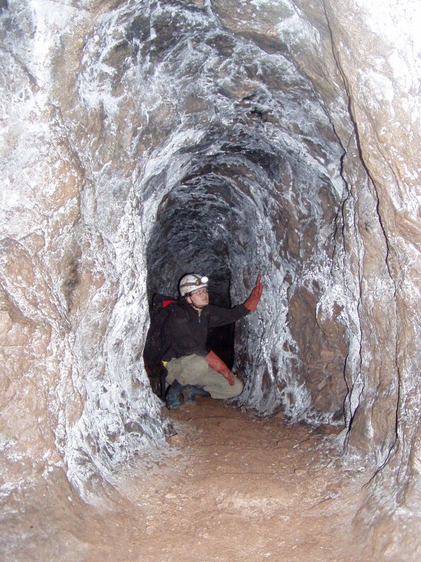
- Góra Miedzianka (inanimate nature reserve) and Kozi Grzbiet (nature monument)
Góra Miedzianka is a hill formed of the Frasnian massive limestones, which are strongly disintegrated by faults and contain tectonic scales of the Fammenian marls. Calcite veins with sulphide and sulpho-salt minerals of Cu, Fe, Zn, Pb and Ni occurring within the limestones, represent original Variscan hydrothermal mineralisation. The secondary ore bodies, enriched in chalcocite and copper carbonates, concentrated in the cementation and oxidation zones, mainly in the Cenozoic paleokarst forms (partly under the Triassic cover of the Devonian). These very irregular ore bodies were mined since the Middle Ages to the half of 20th century (Rubinowski, 1971). It resulted in the occurrence of many kilometres of mine galleries (Fig. 9A), which partly followed paleokarst conduits (some opened to the surface) and numerous surface remnants of mining. The hill ridge is crowned with the natural limestone crags of high landscape value (Fig. 9B). From this ridge both natural landscape of the structural hill ranges and large anthropogenic works (Ostrówka quarry) are visible.
In the neighbouring Kozi Grzbiet hill, the Pleistocene fossils were found in sandy-clayey fills of the karst fissure. Studies of the fossils (mammals, birds, reptiles, amphibians and gastropod shells), typical of moderate climate, enabled to recognise new interglacial period and to divide previous South-Polish Glacial (Mindel) into two glacials (Głazek et al., 1976; Kowalski, 1989; Lindner & Wojtanowicz, 1997).
9a

9b
Fig. 9. Góra Miedzianka: A) mine galery „Zofia” excavated in the 19th century; B) natural rocky ridge of the hill (photo J. Urban)
- Jaworznia (Chelosiowa Jama Nature Reserve)
The site is a hill formed of the Devonian limestones overlain by the Lower Triassic clastic-clayey series (Buntsandstein). The angular unconformity between the Devonian and Triassic is outcropped in the abandoned quarry (Fig. 10). The diversity of facies and structures of the sediments enable the reconstruction of paleorelief during the Early Triassic (Głazek & Romanek, 1978; Nawrocki et al., 2003). Several paleokarst generations were recognized: a) Devonian paleosols formed in freshly deposited limestones emerged during the cyclic events of stopped subsidence (Skompski & Szulczewski, 2000); b) underground forms of the Permian, hydrothermal karst; c) network of the Early Triassic small paleokarst conduits and large horizontal channels and chambers, which are supposed to develop in a sea-fresh water mixing zone; d) Early Triassic surface and underground karst forms (Urban, 2007).

Fig. 10. Jaworznia – angular unconformity between the Devonian limestones and Lower Triassic red siliciclastic-clayey series (photo J. Urban)
The Cenozoic karst period is represented by maze, predominantly horizontal network of passages and chambers of the Chelosiowa Jama-Jaskinia Jaworznicka cave (3670 m, one of the longest Polish caves out of the Tatra Mts), Jaskinia Pajęcza cave (1183 m) and several short caves. The caves, formed in the Neogene, were restored several times. Among the secondary calcite forms are unique aggregates formed due to the slow water freezing during the last glacial in the Pleistocene (Žak et al., 2004).
- Tumlin-Gród (Kręgi Kamienne Nature Reserve)
The Tumlin-Gród partly active quarry is an outcrop of the Lower Triassic sandstones of the Tumlin Member of the Zagnańsk Formation. The sandstones represent deposits of dunes and interdune areas formed in the dry climatic environment. The paleo-dunes display a large-scale cross bedding. Remnants of ephemeral streams, ponds and interdune flats occur among the dunes (Fig. 11). They are characterised by wave ripples, erosion channels as well as dessication cracks and mud flakes. In the quarry also numerous footprints of vertebrates have been found (Gradziński et al., 1979; Ptaszyński & Niedźwiedzki, 2004; Szulc & Becker, 2007). The red “Tumlin sandstones” have been traditional stone material quarried and used in the whole country for construction since the 19th century (Urban & Gągol, 1994).

Fig. 11. Tumlin-Gród – large scale cross lamination of the paleo-dunes with the apparent structure of the ephemeral stream (photo J. Urban)
- Piekło pod Niekłaniem Nature Reserve
The natural rock forms Piekło pod Niekłaniem (Hell near Niekłań village), built of the Lower Jurassic sandstones, are attributed by the exceptional variety of shape and microrelief, which have been conditioned by the specificity of the lithology (structures – Wierzbowski et al., 2006) and relief development. The rock forms are situated in the upper part of extensive hill. The group is composed of three subgroups. The SW subgroup is composed of the most picturesque side-ridge forms: pulpits, bars and mushroom-like forms 5-8 m high (Fig. 12). Two caves formed there due to the subsurface water erosion. The typical microforms of rock surfaces are: caverns, pockets, honeycomb forms, ledges and furrows (Urban, 2005).
Fig. 12. Piekło pod Niekłaniem – cliffs and pulpits in the mid part of the SW rock subgroup; in the left side the cave entrance and natural tunnel through the pulpit (photo J. Urban)
The rock forms were stripped in the Late Pleistocene, supposedly during the last glacial. The eolian abrasion was the main factor excavating these landforms, but they have been permanently shaped by other agents as e.g. linear erosion of subsurface water. The diversity of microrelief has been controlled by the development and degradation of mineral crust (Lindner, 1972; Urban, 2005).
- Jaskinia Raj Nature Reserve
Raj is a karst cave 240 m long, developed in the Devonian limestones. It consists of three main, horizontal passages, which converge near the entrance. Lower part of the passages is filled with the Late Pleistocene loams and sands, covered by the calcite flowstone. Fossils (mammals, birds, reptiles, amphibians, rare fishes and gastropods) occur in almost every 12 layers of the sediments, whereas archaeological artefacts were found in layers no 4 and 6. The cave sediments were deposited in the period before, during and after the first climatic minimum of the last glacial (Late Pleistocene). Archaeological materials (tools) represent the Mousterian Culture of Charentian Group of Neanderthals (Middle Stone Age) (Studies …, 1972).
The Raj cave is abounding with the calcite speleothems, which represent various types: stalactites (ca 47 thousands; average 82,5 stalactites/m2), stalagmites, columns, draperies, curtains, ribs, dumps and pisoids. Soda straw stalactites are the most typical (Fig. 13).
The cave and paleontological-archaeological exposition are accessible for public (www.jaskiniaraj.pl/?lng=en&language=lang).

Fig. 13. Raj cave – the soda straw stalactites are the most numerous and typical for this cave (photo J. Urban)
12. Skotniki – Zajęcza Góra (documentary site)
The sequence exposed in the abandoned quarry comprises the Upper Jurassic and Upper Cretaceous rocks overlain by the transgressive sediments of the Miocene. Thus two phases of the Alpine tectonic movements are perceptible there. The first unconformity (angle ca 3º) is observed between the Oxfordian limestones (dipping 35º N) and Cenomanian sandstone. Thin Cenomanian glauconitic sandstone layer is overlain by the Turonian and Senonian limestones marls and marl-siliceous rocks (gaizes, opokas) bearing flint nodules and horizons. The abraded paleo-surface of the Cretaceous and Jurassic rocks is covered by the sub-horizontal Badenian breccia-conglomerate intercalated with sandy limestone. The coarse-grained rock is composed of fragments of its substratum, often with animal borings (sponges, lamellibranchs, polychaetes, gastropods) and incrustations (bryozoans, polychaetes, lithothamnia). It represents sediment of the littoral depression. It is overlain by the biodetrital and algal limestones bearing also other fossils: foraminifers, gastropods, lamellibranchs, echinoids, fishes (Radwański, 1969; Kwiatkowski, 1985; Walaszczyk, 1992).
- Korytnica (legally not protected)
The site is an area covering several square kilometres, on which the Miocene marine rocks (clays and sands) are abounding with fossils, accessible in artificial pits or due to ploughing. Great number of fossils representing hundreds of taxa and ichnotaxa have been studied there for longer than 150 years (since the 1970 more than 50 papers dedicated to this site have been published). They are: molluscs, corals, polychaetes, ostracods, crabs, stomatopods, cirripedes, crinoids, echinoids, asteroids, ophiuroids, holothurians, fishes, bryozoans, brachiopods, sponges, foraminifers, algae, nannoplankton, dinoflagellates and radiolaria. Molluscs represent the richest and the most diversified group: gastropods, lamellibranchs, chitons, scaphopods, cephalopods. The state of preservation of the fossils enables environmental and ecological studies, as well as analyses of anatomy, classification, evolution, physiology and behaviour of this fauna. The faunal assemblages were similar to the recent ones in tropical or subtropical seas, as the Indian Ocean (Radwański, 1969; Bałuk & Radwański, 1977; Hoffman, 1977; Bałuk, 2006).
- Gacki (3 nature monuments)
In the Gacki abandoned quarry almost whole sequence of the evaporite, gypsum series of the northern part of the Miocene basin crops out. Primary, depositional structures have been preserved in the gypsum. The evaporite formation is characterised by horizontal and vertical diversity of gypsum structures, which are related to the evolution of the basin and its water. In the sequence 15 layers and 7 lithosomes were distinguished. The lithosome A (3 m) is a layer of giant, palisade crystals (and intergrowths) growing directly on the marls of the substratum due to the precipitation from oversaturated brine (Fig. 14). It is overlain with the grass-like selenite intercalated with fine-crystalline gypsum, which formed in the very shallow brine (lithesome B – 3 m). Upper lithosomes C and D (12 m) consist of bedded, sabre-like gypsum deposited in deeper basin during the gradual modification of brine composition. Microcrystaline, laminated gypsum and clastic gypsum (breccias) represent lithosomes E and G (16 m). Their deposition is related to the halite oversaturation. The formation of breccias is connected with the halite dissolution and gypsum redeposition (Kasprzyk, 1999; Bąbel, 1999).

Fig. 14. Gacki – the lowermost unit of the Miocene evaporite series, ca 3 m thick, formed of the palisade of giant gypsum crystals growing directly on the marl substratum (photo J. Urban)
Other interesting geological phenomena in the site are: fault in the gypsum series and underlying marls outcropped in the quarry road-cut, as well as Jaskinia w Krzyżanowicach Górna (Upper Cave in Krzyżanowice) with an archaeological site (Urban et al., 2007).
- Skorocice Nature Reserve
Skorocice Valley is typical karst valley developed due to roof failures of karst subsurface conduits. It is formed in gypsum of lower part of the Miocene evaporite series. The valley consists of two segments: upper, blind part and lower part, which are separated by natural rocky bridge and connected with the Jaskinia Skorocicka (Skorocicka Cave, 352 m long) and Skorocicki Stream. 30 shorter caves (Fig. 15) and numerous surface karst forms – hums, depressions, rock walls – are located within the both parts of the valley. Karst forms represent entrenched and denuded phases of the gypsum speleogenesis and have been formed mainly on the level of the water-table zone (Urban et al., 2007).

Fig. 15. Skorocice – the karst conduit of the Jaskinia Stara (Old Cave), formed due to the gradual incision of the Skorocicki Stream (visible on the passage floor) (photo J. Urban)
* * *
Apart from the sites described above, the following sites from the Świętokrzyskie Mts and Nida Basin are proposed for the European Geoheritage List: Góry Pieprzowe (Cambrian, tectonics, morphology), Biesak-Białogon (Cambrian, Ordovician, tectonics), Zalesie (Ordovician, stratigraphy), Międzygórz (Ordovician, stratigraphy, tectonics), Ostrówka and Todowa Grzęda (Devonian-Carboniferous, stratigraphy, paleogeography), Góra Zelejowa (Devonian, Permian, mineralisation, paleokarst), Góra Żakowa (Devonian, Permian, mineralisation, mining), Wolica (Triassic, stratigraphy, paleoecology), Gagaty Sołtykowskie (Jurassic, dinosaur footprints, fossils, paleoecology), Małogoszcz (Jurassic, paleoecology), Bałtów (Jurassic, paleoecology), Krzemionki Opatowskie (Jurassic, Neogene flint mines), Dobromierz Brachyanticline (Jurassic-Cretaceous, stratigraphy, tectonics), Szydłów (Neogene, paleoecology), Lubania (Jurassic, Neogene, paleogeography, paleoecology), Kamień Plebański (Quaternary, stratigraphy), Wola Chroberska (Quaternary, paleoecology) (Alexandrowicz, 2006 and “Polish database of representative geosites…”, www.iop.krakow.pl/geosites/default.asp). The list is not closed, it will develop along to the progress of investigations and recognition of sites, as well as changes of their status.
The presented above list does not regard the sites, which can be destroyed in active quarries. Among the active quarries being subjects of the scientific interest are e.g.: Wiśniówka (Cambrian), Kowala (Devonian, Permian), Trzuskawica (Devonian, Permian), Kostomłoty (Devonian), Baranów (Triassic), Wierzbica (Jurassic) and Bukowa (Jurassic). They are visited during the scientific conferences (e.g. Szulc & Becker, 2007; Wierzbowski et. al, 2006).
Geotourism
The geoheritage of the Świętokrzyskie Mts. should be properly used for public profit and advantage of earth-science education, which is severely threatened in Europe (van Loon, 2008). Apart from scientific value, the necessary conditions for the geotourism are accessibility and illustrativeness (Alexandrowicz et al., 1992). In a case of most geosites in the Świętokrzyskie Mts., with an exception of some caves and mine galleries, there are not technical problems of access, but the access and educational use of some geosites are limited by their legal protection (see Cabaj & Leśniak, 2005). But recently, the adequate arrangements for earth science education have been prepared in many protected areas, so as to combine effective protection and easy access.
The idea of public geoeducation has had long tradition in the Świętokrzyskie Mts. The first significant steps on this way were geological guidebooks by Kotański (1959, 1968). The next guidebook was published ca 40 years later by Stupnicka and Stempień-Sałek (2001), but again only in Polish. The professional descriptions of many geosites were published in Polish or English guidebooks of conference trips organised in the region.
The idea of the touristic arrangement of the geosites in the vicinity of the Kielce town, was expressed long time before the foundation of the first geoparks, as a concept of the “geological eco-museum” (Rubinowski & Wójcik, 1978). This concept was not realised, but the proper protection and educational usage of geosites was the principal objective of the establishment of the Chęciny-Kielce Landscape Park in 1996 (Urban & Wróblewski, 1999, 2004; Wróblewski, 2000). Subsequently the idea of geological education evolved to the concept of the Centre of Geological Education in Kielce, which was realised in form of the Kielce Geopark (www.geopark-kielce.pl/), established in 2003. The Kielce Geopark centre promotes the geoheritage of the nature reserves (old quarries) situated within the Kielce town and manages these reserves. This management consists in the arrangements of educational trails and provision interpretative panels, publishing leaflets etc. In the Kadzielnia quarry the caves are being prepared for public access. But the principal aim of the Kielce Geopark is the foundation of the Świętokrzyski (Holy Cross Mts) Geopark (Fig. 1) and its adoption to the European Geoparks Network. This Geopark will cover the Kielce agglomeration and its vicinity. 15 geological nature reserves, ca 30 nature monuments and documentary sites, and 30 other geosites are situated within the area of the projected Geopark.
The Kielce town with its old quarries and several tens of geosites in its proximity, is a place, in which the organisation of geotourism and geoeducation should be concentrated. Apart from the Geopark Kielce centre, the Holy Cross Mts. Branch of the Polish Geological Institute (www.pgi.gov.pl/pgi_en) is located in this town. Both the Institute and Geopark centre offer their help in the preparing and organisation of geotourist trips and students practices. The geological museum of the Institute in Kielce and its open-air geological exposition are accessible for public. The paleontological regional collection is also exposed in the National Museum in Kielce (muzeumkielce.net/orla/strona_mnki/index_cis.html). One of the numerous geosites situated in the vicinity of this town is the Raj cave, which is the most famous show cave in Poland.
The second centre of the geotourism can be the Świętokrzyski National Park (www.swietokrzyskipn.org.pl/), situated in the central part of the region (Fig. 1). The geological-paleontological exposition is the part of its Museum. Close to its margins, in the Słupia Nowa town, the Museum of Prehistoric Metallurgy is situated.
The next area of geotourism development is Kamienna River valley (north part of the region), where e.g. the dinosaurs footprints and remnants of other Mesozoic vertebrates were found (see the paper in the same issue of Przegląd Geologiczny).
References
ALEXANDROWICZ Z. 2006 – Framework of European geosites in Poland. Nature Conservation, 62: 63-87. (www.iop.krakow.pl/iop/pliki/04010214-07.pdf)
ALEXANDROWICZ Z., KUĆMIERZ A., URBAN J., OTĘSKA-BUDZYN J. 1992 – Evaluation of inanimate nature of protected areas and objects in Poland (in Polish, English summary). Państwowy Instytut Geologiczny, Warszawa, 140 pp.
BALIŃSKI A., OLEMPSKA E., RACKI G. 2002 – Biotic responses to the Late Devonian global events. Introductory remarks. Acta Palaeontologica Polonica, 47: 186-204.
BAŁUK W. 2006 – Middle Miocene (Badenian) gastropods from Korytnica, Poland. Part V – Addenda et corrigenda ad Prosobranchia. Acta Geologica Polonica, 56: 177-200 (www.geo.uw.edu.pl/agp/table/pdf/56-2/baluk.pdf).
BAŁUK W., RADWAŃSKI A. 1977 – Organic communities and facies development at the Korytnica basin (Middle Miocene, Holy Cross Mts, Central Poland). Acta Geologica Polonica, 27: 85-123.
BĄBEL M. 1999 – Facies and depositional environment of the Nida gypsum deposits (Middle Miocene, Carpathian Foredeep, Southern Poland). Geological Quaterly, 43, 4: 405-428.
BĄBEL M. 2002 – The largest natural crystal in Poland. Acta Geologica Polonica, 52: 251-267.
CABAJ W., LEŚNIAK T. 2005 – Valuation of abiotic nature objects. [In:] Doktor M., Waśkowska-Oliwa A. (eds), 2nd Intern. Conference „Geotour 2005”, 22-24.09.2005, Kraków, Poland. Kraków: 13-15.
CZARNOCKI J. 1928a — Sur le projekt d’une „réservation” dans le massif de Święty Krzyż (Sainte Croix) au point de vue des désidérates géologiques (in Polish, French summary). Zabytki Przyrody Nieożywionej, 1: 30-44.
CZARNOCKI J. 1928b – Coupe de l’Ordovicien à Zalesie (in Polish, French summary). Zabytki Przyrody Nieożywionej, 1: 47-50.
CZARNOCKI J. 1949 — Sur la protection de paysage et des sites scientifiques dans limites de la ville de Kielce (in Polish, French summary). Wiadomości Muzeum Ziemi, 3: 313-320.
DADLEZ R. 2001 – Holy Cross Mts area – crustal structure, geophysical data and general geology. Geological Quaterly, 45: 99-106.
Devonian reefs of Poland 1992. Acta Palaeontologica Polonica, 37: 85-428.
DINGWALL P., WEIGHELL T., BADMAN T. 2005 – Geological world heritage: a global framework. IUCN, www.iucn.org/themes/wcpa/pubs/pdfs/heritage/geology.pdf .
DZIK J., OLEMPSKA E., PISERA A. (eds) 1994 – Ordovician carbonate platform ecosystem of the Holy Cross Mts. Palaeontologia Polonica, 53, part 1, 317 pp, part 2, 136 pp.
GĄGOL J. (ed.) 1996 – Building stones in Poland. Polish Geological Institute, Warszawa-Kielce, 97 pp.
IVANOV A., GINTER M. 1997 – Comments on the Late evonian placoderms from the Holy Cross Mts (Poland). Acta Palaeontologica Polonica, 43: 413-426.
GŁAZEK J., LINDNER L., WYSOCZAŃSKI-MINKOWICZ T. 1976 — Interglacial Mindel I/Mindel II in fossil-bearing karst at Kozi Grzbiet in the Holy Cross Mts. Acta Geologica Polonica, 26: 337-393.
GŁAZEK J. 1989 — Paleokarst of Poland. [In:] Bosak P., Ford D., C., Głazek J., Horaček I. (eds), Paleokarst. Akademia, Praha: 77-105.
GŁAZEK J., ROMANEK A., 1978 – Jaworznia. [In:] Piątkowski T.S., Wagner R. (eds), Symposium on Central European Permian. Guide of Exc., part 2: Zechstein of the Holy Cross Mts., 41-49. Geological Institute, Warszawa.
GRADZIŃSKI R., GĄGOL J., ŚLĄCZKA A. 1979 — The Tumlin sandstone (Holy Cross Mts, Central Poland): Lower Triassic deposits of aeolian dunes and interdune areas. Acta Geologica Polonica, 29: 151-175.
HAKENBERG M., ŚWIDROWSKA J., 1998a – Permian to Late Jurassic evolution of the south-eastern segment of the Polish Trough and its relation to the zones of border faults (in Polish, English summary). Przegląd Geologiczny, 46: 503-508.
HAKENBERG M., ŚWIDROWSKA J. 1998b – Evolution of the Holy Cross Mts segment of the Mid Polish Trough during the Cretaceous. Geological Quaterly, 42: 239-262.
HOFFMAN A. 1977 – Synecology of macrobenthic assemblages of the Korytnica Clays (Middle Miocene, Holy Cross Mts, Poland). Acta Geologica Polonica, 27: 227-280.
HURUK S. 1986 – Block fields of the Holy Cross National Park. Chrońmy Przyrodę Ojczystą, 42, 1: 14-22.
KASPRZYK A. 1999 – Sedimentary evolution of Badenian (Middle Miocene) gypsum deposits in the northern Carpathian Foredeep. Geological Quaterly., 43, 4: 449-465.
KLATKA T. 1962 — Champs de pierres de Łysogóry. Origine et age (in Polish, French summary). Acta Geographica Univ. Lodziensis, 12, 124 pp.
KONON A. 2006 – Buckle folding in the Kielce unit, Holy Cross Mts., central Poland. Acta Geologica Polonica, 56: 375-405 (www.geo.uw.edu.pl/agp/table/pdf/56-4/konon.pdf).
KONON A. 2007 – Strike-slip faulting in the Kielce Unit, Holy Cross Mts., central Poland. Acta Geologica Polonica, 57: 415-441 (www.geo.uw.edu.pl/agp/table/pdf/57-4/konon.pdf).
KOTAŃSKI Z. 1959 — Przewodnik geologiczny po Górach Świętokrzyskich, v. 1-2 (in Polish). Wydawnictwa Geologiczne, Warszawa.
KOTAŃSKI Z. 1968 – Z plecakiem i młotkiem w Góry Świętokrzyskie (in Polish). Wydawnictwa Geologiczne, Warszawa.
KOWALCZEWSKI Z. 1995 – Fundamental stratigraphic problems of the Cambrian in Holy Cross Mts. Geological Quarterly, 39: 449-470.
KOWALSKI K. (ed.) 1989 – History and evolution of the terrestial fauna of Poland (in Polish, English summary). Folia Quaternaria, 59-60, 278 pp.
KOZŁOWSKI S., RADWAN J., WÓJCIK Z. 1965 — The geological reserve Kadzielnia in Kielce (In Polish, English summary). Ochrona Przyrody, 31: 117-160.
KRYSIAK Z. 2000 – Tectonic evolution of the Carpathian Foredeep and its influence on Mioecene sedimentation. Geological Quaterly, 44: 137-156.
KUTEK J. 2001 – The Polish Permo-Mesozoic Rift Basin. In: Ziegler P.A. et al. (eds), Peri-Tethyan rift/wrench basins and passive margins. Peri-Thetys Memoir 6. Mémoires du Museum National d’Historie Naturelle, 186: 213-236.
KUTEK J., GŁAZEK J. 1972 – The Holy Cross area, Central Poland, in the Alpine cycle. Acta Geologica Polonica, 22: 603-652.
KWIATKOWSKI S. 1985 – Stop 2. Mesozoic deposits of the Wójcza-Pińczów Ridge and Miocene deposits along the Holy Cross Mts shore of the Miocene sea. Skotniki – quarry in Zajęcza Góra. [In:] Kotlarczyk J. (ed.), Geotraverse Kraków-Baranów-Rzeszów-Przemyśl-Ustrzyki Dolne-Komańcza-Dukla. Guide to exc. 4. Carpatho-Balkan Geological Assoc. XIII Congr. Cracow, Poland., Geological Institute: 87-89.
LAMARCHE J., MANSY J.L., BERGERAT F., AVERBUCH O., HAKENBERG M., LEWANDOWSKI M., STUPNICKA E., ŚWIDROWSKA J., WAJSPRYCH B., WIECZOREK J. 1999 – Variscan tectonics in the Holy Cross Mts (Poland) and the role of structural inheritance during Alpine tectonics. Tectonophysics 313: 171-186.
LINDNER L. 1972 – Origin and age of the sandstone rocklets of Mt. Piekło near Niekłań (Holy Cross Mts) (in Polish, English summary). Acta Geologica Polonica, 22: 168-180.
LINDNER L., WOJTANOWICZ J. 1997 – Glacial and interglacial units in the Pleistocene of the South Polish Uplands. Quaternary Studies in Poland, 14: 53-69.
MALEC J. 2001 – Sedimentology of deposits from around the Late Caledonian unconformity in the western Holy Cross Mts. Geological Quaterly, 45: 397-415.
MALEC J., TURNAU E. 1997 – Middle Devonian conodont, ostracod and miospore stratigraphy of the Grzegorzowice-Skały section, Holy Cross Mts, Poland. Polish Academy of Sciences Bulletin, Earth Sci., 45: 67-86.
MIGASZEWSKI Z.M., HAŁAS S., DURAKIEWICZ T. 1996 – The age and origin of the calcite mineralization in the Holy Cross Mts based on lithologic-petrographic and isotopic evidence (in Polish, English summary). Przegląd Geologiczny, 44: 275-281.
MIZERSKI W. 1995 – Geotectonic evolution of the Holy Cross Mts. in Central Europe. Biuletyn Państwowego Instytutu Geologicznego, 372: 5-47.
MIZERSKI W. 2004 – The Holy Cross Mountains in the Caledonian, Variscan and Alpine cycles – major problems, open questions. Przegląd Geologiczny, 52: 774-779 (www.pgi.gov.pl/pdf/pg_2004_08_2_14a.pdf).
MODLIŃSKI Z., SZYMAŃSKI B. 2001a – The Ordovician stratigraphy and palaeogeography of the Nida-Holy Cross Mts area, Poland – a rewiev. Geological Quaterly, 45: 417-433.
MODLIŃSKI Z., SZYMAŃSKI B. 2001b – The Silurian of the Nida, Holy Cross Mts and Radom areas, Poland – a rewiev. Geological Qaterly, 45: 435-454.
NARKIEWICZ M. 2002 – Ordovician through earliest Devonian development of the Holy Cross Mts. (Poland) constrains from subsidence analysis and thermal maturity data. Geological Quaterly, 42: 255-266.
NAWROCKI J., DUNLAP J.,. PECSKAY Z., KRZEMIŃSKI I., ŻYLIŃSKA A., FANNING M., KOZŁOWSKI W., SALWA S. SZCZEPANIK Z., TRELA W. 2007 – Late Neoproterozoic to Early Palaeozoic palaeogeography of the Holy Cross Mts. (Central Europe); an integrated approach. Journal of the Geological Society, London, 164: 405-423.
NAWROCKI J., KULETA M. & ZBROJA S., 2003 – Buntsandstein magnetostratigraphy from the northern part of the Holy Cross Mts. Geological Quaterly 47, 3, 253-260.
OLĘDZKI J. 1976 — Influence of differentiation of geological structure on relief in the Holy Cross Mts (in Polish, English summary). Prace i Studia Instytutu Geografii, Uniwersytet Warszawski, 17, Geografia Fizyczna, 6: 5-66.
ORŁOWSKI S. 1988 – Stratigraphy of the Cambrian System in the Holy Cross Mts. Geological Quaterly, 32: 525-532.
PIEŃKOWSKI G. 2004 – The epicontinental Lower Jurassic of Poland. Special Papers, Polish Geological Institute, 12, 154 pp.
PTASZYŃSKI T., NIEDŹWIEDZKI G. 2004 – Late Permian vertebrate tracks from the Tumlin Sandstone, Holy Cross Mountains, Poland. Acta Palaeontologica Polonica, 49: 289-320.
RACKI G. 1993 – Evolution of the bank-to reef complex in the Devonian of the Holy Cross Mts. Acta Palaeontologica Polonica, 37: 87-182.
RACKI G., BULTYNCK P. 1993 – Conodont biostratigraphy of the Middle and Upper Devonian boundary beds in the Kielce area of the Holy Cross Mts. Acta Geologica Polonica, 48: 1-26.
RACKI G., HOUSE M.R. (ed.) 2005 – Late Devonian biotic crisis: ecological, depositional and geochemical records. Palaeogeography, Palaeoclimatology, Palaeoecology, 181: 1-374.
RADWAŃSKI A. 1969 — Lower Tortonian transgression onto the southern slopes of the Holy Cross Mts (in Polish, English summary). Acta Geologica Polonica, 19: 1-164.
RUBINOWSKI Z. 1971 — The non-ferrous metals ores of the Świętokrzyskie Mts and their metallogenic position (in Polish, English summary). Biuletyn Instytutu Geologicznego, 241, 166 pp.
RUBINOWSKI Z., WÓJCIK Z. 1978 — Geological expositions of Kielce and its vicinity with some considerations as regards their protection and exploitation (in Polish, English summary). Prace Muzeum Ziemi, 29: 95-121.
RUTKOWSKI J. 1976 – Detrytyczne osady sarmatu na południowym obrzeżeniu Gór Świętokrzyskich. Polska Akademia Nauk, Prace Geologiczne, 100, 71 pp.
SKOMPSKI S. (ed.) 1995 – Development of the Variscan basin and epi-Variscan cover at the margin of the East European platform. Guide to Exc. A2. XIII Intern. Congress on Carboniferous-Permian. 28.08-2.09.1995. Polish Geological Institute, Warszawa, 42 pp.
SKOMPSKI S., SZULCZEWSKI M. 1994 – Tide dominated Middle Devonian sequence from the northern part of the Holy Cross Mts (Central Poland). Facies, 30: 247-266.
SKOMPSKI S., SZULCZEWSKI M. 2000 – Lofer-type cyclothems in the Upper Devonian of the Holy Cross Mts (central Poland). Acta Geologica Polonica, 50: 393-406.
Studies on Raj cave near Kielce (Poland) and its deposits. Folia Quaternaria, 41, 1972, 148 pp.
STUPNICKA E., STEMPIEŃ-SAŁEK M. 2001 – Poznajemy Góry Świętokrzyskie (in Polish). Wydawnictwo Naukowe PWN, Warszawa, 173 pp.
SZULC J. 2000 – Middle Triassic evolution of the northern peri-Tethys area as influenced by early opening of the Tethys ocean. Annales Societatis Geologorum Poloniae, 70: 1-48.
SZULC J., BECKER A. (eds) 2007 – International workshop on the Triassic of southern Poland, September 3-8, 2007. Fieldtrip Guide. Cracow, 87 pp.
SZULCZEWSKI M. 1971 — Upper Devonian conodonts, stratigraphy and facial development in the Holy Cross Mts. Acta Geologica Polonica, 21: 1-129.
SZULCZEWSKI M. 1995 – Depositional evolution of the Holy Cross Mts. (Poland) in the Devonian and Carboniferous – a review. Geological Quaterly, 39: 471-488.
SZULCZEWSKI M., BEŁKA Z., SKOMPSKI S. 1996 – Chronicle of the drowning carbonate platform: the Devonian-Carboniferous example from the south-western Holy Cross Mts. Sedimentary Geology, 106: 21-46.
SZULCZEWSKI M. DVOŘAK J. (eds) 1995 – Evolution of the Polish-Moravian carbonate platform in the Late Devonian and Early Carboniferous: Holy Cross Mts., Kraków Upland, Moravian Karst. Guide to Exc. B4. XIII Intern. Congress on Carboniferous-Permian. 28.08-2.09.1995. Polish Geological Institute, Warszawa: 1-35.
TRELA W. 1998 – Sedimentary environment of the condensed Ordovician limestones from Mójcza section (Holy Cross Mts.). Geological Quaterly, 42: 289-300.
TRELA W. 2005 – Condensation and phosphatization of the Middle and Upper Ordovician limestones on the Małopolska Block (Poland): response to palaeooceanographic conditions. Sedimentary Geology, 178: 219-236.
URBAN J. 1990 — Protection of inanimate nature objects in the Góry Świętokrzyskie (Holy Cross Mts) province (in Polish, English summary). Rocznik Świętokrzyski KTN, 17: 47-79.
URBAN J. 2005 – Pseudokarst caves as an evidence of sandstone tors evolution – a case study of Niekłań, the Świętokrzyskie Mts., central Poland. Ferrantia, 44: 173-177 (http://www.mnhn.lu/recherche/ferrantia/publications/Ferrantia44.pdf).
URBAN J. 2007 – Permian to Triassic paleokarst of the Świętokrzyskie (Holy Cross) Mts., Central Poland. Kwartalnik AGH, Geologia, 33: 5-50 (http://journals.bg.agh.edu.pl/GEOLOGIA/2007-01/Geologia_2007_1_01.pdf).
URBAN J., ANDREJCHUK V., GUBAŁA J., KASZA A. 2007 – Caves in gypsum of the Southern Poland and the Western Ukraine – a comparison. Kras i Speleologia, 12: 15-38.
URBAN J., GĄGOL J. 1994 – Quarries of sandstones in ancient centres of stone mining in the northern part of the Holy Cross region (central Poland) as monuments of engineering and nature (in Polish, English summary). Przegląd Geologiczny, 42: 193-200.
URBAN J., WRÓBLEWSKI T. 1999 – Representative geosites of the Góry Świętokrzyskie (Holy Cross Mts) and Nida Basin, Central Poland. Polish Geological Institute, Special Papers, 2: 61-70.
URBAN J., WRÓBLEWSKI T. 2004 – Chęciny-Kielce Landscape Park – an example of officially not proclaimed geopark. Polish Geological Institute, Special Papers, 13: 131-136.
VAN LOON A. J. 2008 – Geological education of the future. Science Direct, Earth Sci. Rev., 86: 247-254.
VIEREK A. 2007 – Transitional reef-to-basin facies of Lower Frasnian limestones determined by microfacies analysis (Wietrznia, Holy Cross Mts, Poland). Facies, 53: 141-155 (www.springerlink.com/content/p7q9g7wvx0563287/fulltext.pdf).
WAGNER R., 1994 – Stratigraphy and evolution of the Zechstein basin in the Polish lowland (in Polish, English summary). Państwowy Instytut Geologiczny, Prace, 146, 1-71.
WALASZCZYK I. 1992 — Turonian through Santonian deposits of the Central Polish Uplands, their facies development, inoceramid paleontology and stratigraphy. Acta Geologica Polonica, 42: 1-122.
WIERZBOWSKI A., AUBRECHT R., GOLONKA J., GUTOWSKI J., KROBICKI M., MATYJA B.A., PIEŃKOWSKI G., UCHMAN A. (eds) 2006 – Jurassic of Poland and adjacent Slovakian Carpathians. Field trip guidebook of 17th International Congress on the Jurassic System, Poland, Kraków, September 6-18, 2006. Polish Geological Institute, Warszawa, pp. 235.
WIMBLEDON W. 1999 –Geosites – an International Union of Geological Sciences initiative to conserve our geological heritage. Polish Geological Institute, Special Papers, 2: 5-8.
WRÓBLEWSKI T. 2000 – Geodiversity conservation in the Góry Świętokrzyskie region (in Polish, English summary); with Map of protected areas and objects of inanimate nature 1:200 000. Państwowy Instytut Geologiczny, Warszawa, 88 pp.
ŽAK K., URBAN J., CILEK V., HERCMAN H. 2004 – Cryogenic cave calcite from the several Central European caves: age, carbon and oxygen isotopes and genetic model. Chemical Geology, 206: 119-136.
ŻYLIŃSKA A., SZCZEPANIK Z., SALWA S. 2006 – Cambrian of the Holy Cross Mts, Poland; biostratigraphy of the Wiśniówka hill succesion. Acta Geologica Polonica, 56: 443-461 (http://www.geo.uw.edu.pl/agp/table/pdf/56-4/zylinska.pdf).